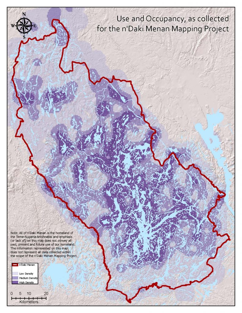
Traditional Use and Occupancy mapping
Teme-Augama Anishnabai have been documenting their historical information orally, since time immemorial. Over the years, others have tried to document our information; cartographers, archaeologists, anthropologists, geologists, Hudson’s Bay Post staff, etc. In the 1970’s, while preparing our land claim, we began to document our history on the land in our own terms. This has been ongoing. In 2013, we began Temagami First Nation’s traditional use and occupancy mapping study. This is the first time that our information is being collected in our GIS (Geographic Information Systems) database.
It is a legacy project that records the lives and stories of Teme-Augama Anishnabai across n’Daki Menan. This work was established with multiple meaningful and necessary goals in mind. The n’Daki Menan Mapping project preserves knowledge from elders and supports TAA/TFN’s rights and claims in legal settings by providing evidence of title and rights. The information gathered allows Lands and Resources staff to effectively respond to mining and forestry applications with a full understanding of the impact that development will have.
OCAP: Ownership, Control, Access, and Possession
This principle guides how L&R handles information. TAA/TFN information belongs to TAA/TFN, and so we keep this information, and we determine who has access, and when. External agencies cannot keep TAA/TFN information, they must come to us to get that information. Temagami First Nation has an extensive Conditions of Release and Use Agreement, which allows us to exchange information with third parties.
Use
Use encompasses the collection of resources (such as gathering, trapping), and travel throughout the area. Use will often have a bigger footprint than occupancy, and it is important to note that use is not always a reflection of occupancy as it includes harvesting done by people who travel to and from other First Nations. Mapping use can demonstrate changes over time.
Occupancy
Teme-Augama Anishnabai have been the occupants of n’Daki Menan from time immemorial. Occupancy includes ecological knowledge, homes, language, and stories. Language describes the features and characteristics of an area. The stories/accounts of an area are intrinsically linked to the landscape they come from and are an integral part of occupancy. Although occupancy goes beyond a recorded location, it can be visualized with a stable boundary over long periods of time.
TEK knowledge
TEK stands for Traditional Ecological Knowledge. There is a great deal of overlap between traditional use and occupancy sites and significant ecological sites, examples include fish spawning sites, moose calving sites and species at risk bird nests. Traditional ecological knowledge is not just location-based and includes information about the timing of gathering, the techniques of use, and the giving of thanks.
How do we collect it?
Information to support the use and occupancy mapping can be collected in a variety of ways. A huge portion of information comes from interviewing people who have information that they would like to share to the project. We also collect information through archaeological reports, historical field notes and Hudson Bay records.
The interviews done in this project create “map biographies”-a document that records their lives throughout n’Daki Menan. The process that we use to interview elder’s (and others) has been rigorously vetted, and the information collected is defensible in court.
Maps as a Tool
A map is just a simplified model of the real world.
Maps can be beautiful, but they must also serve as an important tool. Their visual components, despite being two dimensional, can still provide a clear understanding of the landscape. Something as simple as visually representing the direction of water flow can be extremely helpful when considering the risks of flooding or the spread of contaminated water.
Maps help people visualize both problems and potential. A well-done map should present its viewer with all the relevant information needed to assess a situation. Lands and Resources frequently uses maps to provide spatial context and assist in the decision-making process.
The referral database
Most applications that come through Lands and Resources are run through our referrals database. Storing this information digitally allows for easy access (by the L&R team) and presentation of this information.
This has been built up over time, and includes important ecology sites, locations of traditional land use, historic points of interest and more. Anything that we want to see protected or avoided goes into the spatial database, and this allows us to have a quick and defendable methodology for dealing with many types of applications.
Lake Names in Anishinaabemowin
